

|
|
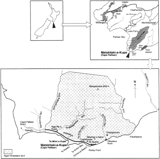 |
| Fig. 1 Location of Matakitaki-a-Kupe. |
Archaeological Studies At Palliser Bay
Place names and archaeological evidence that indicate that the southern Wairarapa area, and in particular Palliser Bay which includes Matakitaki-a-Kupe, has had several periods of settlement over the past 1000 years. Many of the archaeological sites that are visible indicate extensive horticultural crop production was undertaken in the area. They include an extensive series of protective stone walls, kumara storage pits, stone and soil mounds, and terraces. Analysis of the contents of middens (refuse pits) provide an indication of the diet of the inhabitants. Topsoil between the stone walls modified by the addition of charcoal and beach gravel give further insight into crop production practices (Leach 1984). Radiocarbon dating of wood charcoal excavated from the sites studied, indicates that some of the sites had been occupied from as early as the 12th century (Leach 1979).
Located within the land owned by Ngati Hinewaka is a significant unfortified occupation site, which was identified by Te Whaiti (1994) as Orangikorero. It is terraced and includes several raised-rim kumara storage pits. Studies indicate that the early inhabitants practised a subsistence economy and that the land between the sea and the foothills was used for gardening. They also fished offshore, gathered shellfish, fished in streams and rivers and snared birds in the forests. At that time forests extended almost to the sea and the riverbanks were stable and grassed (Leach 1984). Clearance of vegetation resulted in erosion, and eventually silting of the inter-tidal areas and a decline in the population of some shellfish species. Leach and Leach (1979) concluded that the settlements in Palliser Bay were eventually abandoned in the early 16th century, due to a decline in climatic conditions which made kumara (Ipomoea batatas) and gourd (Lagenaria siceraria) culture marginal, in addition to the depletion of other important food reserves.
European Settlement of the Area
From 1846 the Cape Palliser area was leased to European runholders. In 1853 major land purchases were made on behalf of the government, enabling runholders to freehold large areas. By then pastoralism was well established and flourishing. Since 1860 the Matakitaki block has been leased by a succession of farmers who cleared the vegetation on the coastal terraces and steep slopes and stocked first cattle and then converted to smaller holdings of sheep when refrigerated shipping in the 1860s opened up new overseas markets (Aburn 1987).
Matakitaki-A-Kupe Today
Site Status
Much of the land at Matakitaki-a-Kupe is managed by a trust, whose members are Ngati Hinewaka. The land is divided into several blocks each of which is owned by whanau (extended family) groups within the hapu. The whole Matakitaki-a-Kupe area has special spiritual significance and is regarded by them as a waahi tapu (sacred place). For this reason they take seriously their responsibilities and duties as the kaitiaki (caretakers/protectors; Te Whaiti 1994). Since 1986 three of the blocks have been covered by an Open Space Covenant administered by the Queen Elizabeth II National Trust. The coastal strip from the Mangatoetoe Stream to the Waitutuma Stream is designated an historic area as detailed earlier.
Farming potential
From an agricultural perspective the land is classed as North Island hard hill country (Blaschke 1981). A gently sloping coastal plain extends from the sea for approximately 400 metres to the base of very steep hills, which rise to an inland-forested plateau and then to open tops at over 1000 metres. The coastal plain is approximately 140 hectares and is ideal for grazing, especially as water is available. Cattle have been run on this block for several years over the summer months. It is estimated that the area should carry approximately 400 weaners with the numbers being reduced as the stock mature (Burns 1995). Sheep have not been grazed on the land since the early 1980s.
Fire
Over the summer and autumn months dry grass which covers the coastal strip to the road creates a fire hazard. On 5 February 1990, a campfire swept through most of the Matakitaki blocks east of the lighthouse burning large areas of native vegetation. Details are recorded in an unpublished Department of Conservation debriefing report (Borger n.d.). Access to the area is now controlled by the owners who restrict the number of campers. Grazing cattle on the coastal plain over summer keeps the grass relatively short and reduces the fire risk. An earlier fire in 1988 caused some minor damage to vegetation, but it was not nearly as extensive as the later 1990 fire. Controlling public access and camping has also reduced activities such as cutting of trees and shrubs for firewood, and driving recreational vehicles over the land. These were contributing to a general degradation of the landscape.
Vegetation of the Area
Druce (1971) writing of the flora of the Aorangi range commented about the southern part near Cape Palliser — "If any area on the southern North Island coastline should be declared a National Coastline Park this is it!"
Ngati Hinewaka land comprises the southern-most part of the Aorangi Ranges. The area includes the coastal strip between the Mangatoetoe stream in the west and the Waitutuma Stream in the east with a block of steep coastal ranges behind this area rising up to and including Mangatoetoe (856m), the southern-most mountain in the Aorangi Ranges (see Figure 1). The mountains rise steeply from the coastal strip and underlying greywacke, with faults running through NNE-SSW, are easily eroded. Natural erosion has been enhanced by deforestation from man-made fires, starting in pre-European times and occurring at regular intervals up until the present day. Introduced animals including deer, goats, pigs, possums and rabbits, and the grazing of sheep and cattle have also contributed to erosion (Wardle 1967).
The original forest climax community of mahoe (Melicytis ramiflorus), hinau (Elaeocarpus dentatus), rewarewa (Knightia excelsa) hardwood forest with podocarps is presumed to have grown right down to the coastal strip, but this has long since been replaced by fire-induced seral plant communities. Kanuka (Kunzea ericoides) scrub regrowth is the main response to fire. Tall kanuka occurs in patches on the hillsides and on the older stable shingle fans at the base of the hills where regrowth has occurred. Prominent at former Maori habitation sites are groves of karaka (Corynocarpus laevigatus). One was described by Leach (1991) as being "archaeologically significant". Recently located colonies of rengarenga lily (Arthropodium cirratum), are also considered indicative of early Maori occupation (Harris and Te Whaiti 1995).
The steep coastal hillsides most recently razed by fire are well colonised by European pasture grasses. Many native plants are starting to shade out the pasture grasses particularly in the more sheltered gullies and ravines. Ti kouka (Cordyline australis), kowhai (Sophora microphylla), mahoe (Melicytus ramiflorus), kanuka (Kunzea ericoides), tauhinu (Cassinia leptophylla), ngaio (Myoporum laetum) and several species of Coprosma are the main shrub species regenerating on the steep hillsides.
Herbaceous species growing on the hillsides, and also in places amongst the coastal rocks, include wharariki (Phormium cookianum) and karamea (Aciphylla squarrosa) with scrambling lianes such as poananga (Clematis forsteri), aka kiore (Parsonsia capsularis) and Muehlenbeckia complexa and M. axillaris. Shrubs occupying these sites include Coprosma repens, Cape Palliser daisy (Brachyglottis greyii) and Coprosma propinqua.
This area of the coast contains a number of rare and endangered plants (de Lange 1993). Near Nga Ra o Kupe (the sails of Kupe) seven plants of Muehlenbeckia astonii can be found. Only 37 other plants of this species remain in the wild in the North Island. The survival of this species is complicated because the plants are dioecious, (having separate male and female plants); these survivors each grow some distance from a plant of the other sex (de Lange and Silberry 1992). Another rare species of muehlenbeckia, M. ephedroides, is found growing in two colonies on the beach gravel. Other rare plants found in the area include a fern Pleurosorus rutifolius, and two grasses, Rytidosperma petrosum and Chionochloa beadiei which is endemic to this coastal region.
Boxthorn (Lycium ferocissimum) is the only exotic plant that has become established to any significant extent in the area and Timmins (1996) identified this plant as being the only weed of particular threat to the revegetation/grazing programme. She noted that tall (2-4m) wide bushes are common in the vicinity of the lighthouse and that localised patches have coalesced to form impenetrable thickets. All the boxthorn plants are mature specimens and it appears that occasional stocking with cattle has kept new seedlings in check. The bare shingle screes on the hill slopes appear to be free of boxthorn as are the hill slopes clothed in regenerating native cover.
The Restoration Project
The aims of the restoration project are:
- To restore the natural vegetation on the steep coastal hills that have been grazed and burned.
- To generate income
by grazing cattle on the approximately 140ha of coastal plain.
- To provide training for members of the Trust, in basic horticultural techniques including plant propagation and production, using the nursery constructed for this purpose, and in native forest restoration.
In this plan, the steep coastal hills (approximately 200 hectares) are to be restored to natural vegetation cover. Prior to 1990, natural regeneration of vegetation on the coastal hills was taking place and some areas had a good cover of a mixture of trees including kanuka, manuka (Leptospermum scoparium), mahoe, ti kouka, kowhai, ngaio and tauhinu. Karaka trees were well established on the lower slopes in addition to numerous herbaceous plants. The 1990 fire destroyed most of the trees on the steep hillsides although many of the karaka trees on the lower slopes survived. The fire did not reach as far as neighbouring Ngapotiki Station where vegetation, which includes the above species, is now well established. On some sections of the hillsides, natural regeneration has been rapid either from regrowth from plants that were damaged but not killed by the fire, (for example ti kouka), or from seeds. Kowhai has re-established particularly well and many of the seedlings which have grown since the 1990 fire are now up to 2 metres in height. Regeneration is most rapid in the more moist and shaded valleys and slower on the drier north facing slopes where exotic grasses are still dominant. However even on these dry sites, kowhai seedlings are managing to emerge through the grass and make good growth.
Fencing
Porteous (1993) noted that the top priority in any programme to manage and restore forest remnants is to exclude stock. Cattle have been run on the Matakitaki-a-Kupe blocks over the summer months since 1991 to provide income for the owners. Although cattle avoid the steep slopes, they tend to move up the ravines in search of water and browse and trample the vegetation along the stream beds. Sheep which will graze steep slopes have not been farmed on these blocks for at least 20 years. In fact a condition of the Queen Elizabeth II National Trust covenant that covers parts of the land specifically excludes sheep from the covenanted areas. A priority of the revegetation programme will be to fence the base of the steep slopes to confine the cattle to the coastal plain. However some very steep sections are unstable, and continuous erosion is preventing the establishment of vegetation. Here the technique of laying and pegging down capsule bearing branches of manuka on the steeper slopes as described by Porteous (1993) will be tried.
It is interesting to compare Matakitaki-a-Kupe with parts of Tora Station, some 20 km to the North East. Some of the steep coastal hills at Tora were fenced off in the mid 1970s as grazing by sheep and subsequent erosion had left them in an unstable condition. During Cyclone Bola in 1988, this area was subjected to very high rainfall over a short period. Within the fenced areas sufficient vegetation had established to prevent the severe erosion and slumping that badly affected parts of the coastal hills with no vegetation cover. The first plant to become established on these sites was tauhinu (Tyer 1996 personal communication).
Weeds
Timmins (1996) recommended that a priority for the revegetation programme should be to remove the boxthorn plants and monitor the area for regrowth and new seedlings. Other weed species identified in the area include; Cape Ivy (Senecio angulatus), sweet briar (Rubus rubiginosa), broom (Cytissus scoparius), and thistles Carduus nutans, Cirsium vulgare, and C. arvense. Most of these species were not considered likely to present a significant problem but Timmins (ibid) recommended that they should be removed. No gorse (Ulex europeus) is present.
Pests
Rabbits are numerous on the coastal plain around and within the boxthorn thickets but not on the steep hillsides. Pindone baits will be laid to control them. Possum browsing in the coastal area does not appear to present a serious threat to the revegetation programme. Possums tend to take refuge during the day in clumps of wharariki. A trapping programme will be undertaken to ascertain their numbers. Possums are attracted to rengarenga and they will browse this plant in preference to others (Harris 1997 pers. obs.). Browsing on rengarenga is a good indicator of possums and regular inspections of the rengarenga colonies have not shown any significant damage.
Wardle (1966) reported that browsing by introduced herbivores including deer, goats and possums has modified the understorey in the mahoe-hinau-rewarewa forest that predominates further inland from the coast. The understorey now consists almost entirely of unpalatable species such as the fern (Blechnum discolor) and horopito (Pseudowintera colorata).
The Nursery
The nursery is adjacent to the one of the houses near the lighthouse. It occupies an area of 40 square metres and is surrounded by 2m high windbreak cloth to give shelter from the frequent strong winds that blow from the south and the north west. Two taupata (Coprosma repens) trees were retained to provide shade. The floor has been terraced and covered with weed cloth and a 50mm layer of 20mm metal chip. The nursery includes a glass-clad cold frame for propagating plants from seed and cuttings, a potting shed and an outdoor potting bench.
The main purpose of the nursery is to provide training in plant propagation and production techniques for members of the hapu and to produce plants endemic to the area for landscaping around the houses. An interpretive centre will eventually be constructed here. To complement practical on site training, staff from The Open Polytechnic Natural Resources Centre will conduct a series of classes based on The Open Polytechnic New Zealand Native Plants course.
In keeping with established native forest restoration practices (Porteous 1993), seed is being only collected from plants in the area to be revegetated. Seed of the following species was collected on 1 March 1997: Taupata (Coprosma repens), ngaio (Myoporum laetum), kowhai (Sophora microphylla), poananga (Clematis forsteri), harakeke (Phormium tenax), ti kouka (Cordyline australis), kanuka (Kunzea ericioides), maukoro (Carmichaelia arborea), kaikomako (Pennantia corymbosa), karaka (Corynocarpus laevigatus), rengarenga (Arthropodium cirratum), and wharangi (Melicope ternata). These were sown in trays on 4 June 1997. At the same time cuttings of shrubby tororaro (Muehlenbeckia astonii), Cape Palliser daisy (Brachyglottis greyii), puka (Griselinia lucida) and a koromiko (Hebe salicifolia) were taken. The cuttings were inserted into trays of a 50:50 sharp sand:peat mixture and placed in a cold frame.
Seedlings and rooted cuttings will be potted up and grown on until they are large enough to plant out. Commercial peat-based potting medium is being used at present; however, it is intended that a medium based on composted seaweed with added sand and nutrients will be prepared and trialed on site to attempt to reduce costs.
Discussion
Maori as tangata whenua (people of the land) have a special relationship with the land. Just as the tribes are closely linked by a network of genealogical connections, so are they related spiritually to their ancestral lands (Patterson 1992). Firth (1972) stated that the entire Maori culture has been centred around issues relating to land. From their ancestral land, Maori find their place to stand (turangawaewae). Bennett (1979) recorded that — "the essence of turangawaewae is that the land is an outward and visible sign of something that is deeply spiritual and it is a source of nourishment to the inner man rather than to his physical needs. His identity belongs there, his sense of self awareness begins there and his sense of mana and importance belong there". Traditional Maori attitudes to the natural world reflect the relationships created through Papatuanuku (Earth mother) and Ranginui (Sky father). All living things are their descendants and are related. The interdependence between people and their environment creates a sense of belonging to nature. Humans are born from Mother earth and return to her on their death (Marsden 1977).
For Ngati Hinewaka, their turangawaewae is Matakitaki-a-Kupe — the place where many generations of their tipuna (ancestors) lie beneath its soil.
In this context, the restoration project is part of an overall kaupapa (plan) for Ngati Hinewaka to revive their traditional matauranga (knowledge and skills) so they can hold onto their past while making their way into the future. Ngati Hinewaka as kaitiaki or guardians of their land believe that they have a responsibility to care for and manage the land wisely, not only for future generations, but also for those who have gone before. Because the revegetation part of the project will allow the hapu to work towards re-creating the physical environment of their tipuna (ancestors), the project represents more than just restoring the forest cover on the land for future generations.
In addition to the spiritual considerations and the revival of traditional knowledge, the project provides other practical benefits. These include stabilising the steep hillsides and preventing further erosion, improving the aesthetic appearance and attraction of the physical landscape, and protecting and proliferating rare and endangered plant species that grow in the area. The project will also provide social and educational benefits as it will provide training and skills for members of the hapu horticulture, agriculture and conservation, and will allow Ngati Hinewaka to become better-informed custodians of the land. Income necessary for costs associated with maintenance and restoration will be generated from grazing cattle. Grazing will provide the additional benefit of reducing fire risk over the summer months.
Long-term economic potential for the area could focus on tourism including elements of eco- and ethno-tourism. This might provide employment opportunities as well as generating income. Restoration of the physical landscape will make this possibility more likely. Ideally the whole area including the coastal plain should be restored to natural vegetation. However, in order to generate income from grazing, fencing off the steep hills for revegetation while allowing grazing on the flat land, is an acceptable compromise. It is an example of nature conservation in a production environment.
Acknowledgements
The author acknowledges the assistance and cooperation of Ngati Hinewaka and in particular Haami Te Whaiti in providing information for this paper. Financial assistance for this project was provided by the Environment and Heritage Fund of the New Zealand Lottery Grants Board.
References
Aburn, A. 1987. Pirinoa — People and Pasture. Carterton, New Zealand: Roydhouse Publishing Ltd.
Bennett, Manuhuia, 1979. Te Kupu Whakamutunga: The last Word. In: He Matapuna — a source: Some Maori perspectives. Wellington. Te Kaunihera Whakakaupapa mo Aotearoa. The New Zealand Planning Council. pp 74-79.
Blaschke, P. M. 1981. Analysis of New Zealand's vegetation cover using Land Resource Inventory data. New Zealand Journal of Ecology. 4: 1-19.
Burns, R. 1995. Report on the visit to the Trust land at Palliser Bay on 16 January 1995. Unpublished report.
de Lange, P. J. and Silberry, T. 1992. Saving the shrubby tororaro (Muehlenbeckia astonii Petrie) — an urban approach to threatened plant conservation. Proceedings Royal New Zealand Institute of Horticulture Annual Conference 1992, 1:99-105.
de Lange, P. J. 1993. Unpublished data on file, Wellington: Department of Conservation, P.O Box 10-420, Wellington, New Zealand.
Department of Conservation Wellington Conservancy, 1990. Cape Palliser Fire Debriefing: 19 February 1990. Unpublished.
Druce, A. P. 1971. The Flora of the Aorangi Range, Southern Wairarapa. Wellington Botanical Society Bulletin. 37: 4-29.
Firth, R. 1973. Economics of the New Zealand Maori. Wellington: Government Printer. (Reprint of first edition 1929)
Harris, G. F. and Te Whaiti, Haami 1996. Rengarenga Lilies and Maori Occupation at Matakitaki-a-Kupe (Cape Palliser). Journal of the Polynesian Society. 105: 271-284.
Leach, B. F. 1991. Matakitaki-a-Kupe Coastal Area. Submission to NZ Historical Places Trust. P.O. Box 2629, Wellington.
Leach, B. F. and H. M. Leach (eds) 1979. Prehistoric Man in Palliser Bay. National Museum of New Zealand Bulletin 21.
Leach, H. M. 1979. Evidence of Prehistoric Gardens in Eastern Palliser Bay, in B. F. Leach and H. M. Leach. Prehistoric Man in Palliser Bay. National Museum of New Zealand Bulletin 21: 137-161.
Leach, H. M. 1984. 1,000 Years of Gardening in New Zealand. Wellington: A. H. and A. W. Read.
Marsden, Maori 1975. God, Man and Universe: a Maori View. In: Te Ao Hurihuri — The world moves on. King, M. (ed). Hicks Smith and Sons/Methuen New Zealand. pp 86-106.
Orbell, M. 1985. The Natural World of the Maori. Auckland. Collins.
Patterson, J. 1992. Exploring Maori values. Palmerston North. Dunmore Press.
Porteous, T. 1993. Native Forest Restoration — A practical guide for landowners. Queen Elizabeth II National Trust. Wellington, New Zealand.
Te Whaiti. Haami 1994. Matakitaki-a-Kupe. Historic Places. July 1994: 28-30.
Timmins, S. M. 1996. Weed and Animal Pest Status of Ngati Hinewaka land at Matakitaki-a-Kupe: Ecologist's Report. Unpublished report.
Wardle, J. 1967. Vegetation of the Aorangi Range, Southern Wairarapa. New Zealand Journal of Botany. 5: 22-48.
![]()
- View
this paper as a PDF of the original proceedings

- Full
conference proceedings available as a hardcopy from the RNZIH
Reproduced from: New Zealand Plants and their Story
Proceedings of a conference held in Wellington, 1-3 October 1999
ISBN 0-9597756-3-3
Home | Journal
| Newsletter | Conferences
Awards | Join
RNZIH | RNZIH Directory | Links
© 20002024 Royal New Zealand Institute of Horticulture
Last updated: April 25, 2004