

|
|
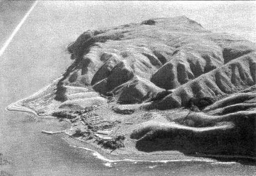 |
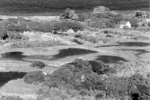
| Fig. 1 Mana Island, incised valley system drains to the east. |
This is a chapter in the story about plants and Mana Island. It covers the history and process of restoring the Island through an active revegetation programme. First let me set the scene.
Located approximately 4km off the entrance to Porirua Harbour and almost midway between Kapiti Island and Wellington Harbour, Mana Island has a character of its own. From some directions it appears not to fit the local coastal landscape due to its plateau like top and abrupt edge. This is a remnant of a much larger peneplain that once extended into Cook Strait and although not obvious from a distance an incised valley system drains to the east terminating in a wetland and a sheltered landing place. To the north and west the cliffs are over 100m high and are exposed and windswept from the prevailing winds as they funnel through the strait.
The physical connection to the mainland is more understandable when you stand on the island and look north and south; even so it is in sharp contrast to Kapiti Island's softer higher profile and well-vegetated slopes. Both islands are equally important from a conservation perspective but Mana's 217 hectares presents a special challenge to those involved with its long-term welfare.
While my own involvement extends back only 25 years, Kupe is said to have visited the island about 700-900 AD. He named it Mana o Kupe Ki Aotearoa. Captain Cook in the 1700's called it Table Island. By the 1820's, Te Rauparaha and Te Rangihaeatea had houses and a large Pa on the island. It was by all accounts a favoured site for cultivation, trading and as a staging post for coastal travel. In 1832 the island was purchased from the Ngati Toa by three Sydney merchants, and one of these, Bell, was assigned to live and farm on the island. He bought with him 10 cattle, 102 sheep and 2 tons of hay and set up a trading station supplying meat, vegetables, and other produce to passing ships and whalers.
An early map of the island shows where 1 acre had been surveyed off for "BelIs Garden" on what is probably the warmest and best soil on the island. There is still evidence of a ditch and bank to keep animals out. This site is regarded as being the first documented evidence of European gardening in the country. When Bell died some years later it is recorded that there was insufficient wood on the island to build him a coffin so he was buried in a rum barrel. It was always a concern of mine that during the construction of the wetland in 1998 we would find an oaken stave or two. The only piece of wood found was sent away for analysis and was confirmed as akeake, an exciting find in itself.
Least you are beginning to wonder if this is a history paper, it is important to understand that following Bell's initial attempt at farming the island underwent continuous change by a succession of owners and lessees for the next 150 years. It is a fascinating story and I often wonder how the natural vegetation patterns changed over this time. In 1973 the Ministry of Agriculture and Fisheries took the island over as a quarantine station and established new buildings, fences and research facilities. When the MAF programme was terminated in 1978 due to a suspected scrapie outbreak, the Department of Lands and Survey farmed cattle on the island until their removal six years later. The farming era is still evident in the landscape today where remnant shelterbelts, farm ponds, fence patterns and other relics remain. Like the archaeological history of the Maori, the efforts of Bell, the whalers, lighthouse keepers and others, it is important to record the horticulture and agriculture uses of the island. Regrettably a legacy of weed species originating from this time are a potential threat to the restoration programme and include boxthorn, bone seed, karo, pampas, kikuyu and Tasmanian ngaio. Some of these are now subject to an aggressive weed control programme.
When the Department of Lands and Survey become directly responsible for the island it recognised the need to protect the remaining natural communities and threatened plants and animals that had somehow survived. The most natural areas were found on the shoreline and cliffs, comprised typically of pohuehue, propinqua, coprosma, taupata, wharariki and other coastal species, they also included threatened plants, Melicytus obovatus, rengarenga, and Jersey fern. The only coastal forest of note occupied a steep east-facing gully with the upper reaches dominated by regenerating kanuka/manuka. Deeper in the gully, away from the worst of the wind, and no doubt fire and animals, kohekohe, wharangi, milk tree, mapou, pigeonwood, karaka, and sub-canopy species provided an indication of the forest that would have occurred on Mana originally.
Somehow sufficient habitat remained to support six reptile species including the threatened goldstripe gecko and McGregor's skink. The Cook Strait giant weta remained abundant in the grassland and shrub communities and 37 bird species are known to occur on or around the island.
With all the stock removed from the island and the only mammals left being mice, the Department of Lands and Survey set about producing a land-use study, concept and management plan and a number of scientific investigations. Of these the botanical survey by Timmins, S. M.; Ogle, C.; & Atkinson, I. A. E. 1987 covering the vegetation and vascular flora of Mana has been the most significant from a revegetation point of view. The lack of indigenous seral communities and the limited species range generally combined to illustrate that this was indeed a degraded ecology.
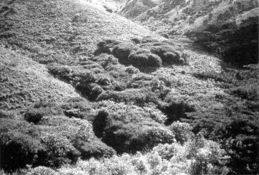 |
| Fig. 2 Early years of the programme getting cover established. |
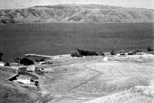 |
| Fig. 3 Early pastoral site of new wetland. |
 |
| Fig. 4 The creation of new wetland now provides valuable habitat. |
Total plant species
on Mana = 325
| Native | Exotic | ||
| trees and shrubs | 40 | trees | 9 |
| lianes | 10 | lianes | 1 |
| dicot herbs | 48 | dicot herbs | 112 |
| grasses | 10 | grasses | 29 |
| sedges | 11 | sedges | 1 |
| rushes | 8 | rushes | 2 |
| ferns | 31 | ||
| orchids | 7 | ||
| monocot herbs | 6 | ||
| Total | 171 | 154 |
As wide public interest had been generated through the management plan process and permanent staff appointed to the island it was timely to commence a planting programme. We can now look back and consider the programme from the time it first commenced. In the first two years 39,000 trees and shrubs comprising ngaio, kohuhu, tauhinu, karamu, fivefinger and titoki were planted around the lower valley edges, foreshore and protected hill slopes. In spite of favourable growing conditions, losses were high due to competition from the destocked and well-fertilised grassland and the summer dry period. Although the programme got off to a good start, more cost effective methods were sought through weed management, direct seeding, planting techniques, irrigation, and better selection of species. The results of this effort were in part successful, even if a little unsympathetic. Over 20 years later it is still possible to see the plantation type approach that resulted from the spray lines and irrigation layout.
In spite of management changes to the Department's Native Plant Nursery at Taupo that had supplied the majority of the stock, by 1991, over 120,000 plants had been put in the ground and parts of the island were beginning to change. The rank grassland showed a small recovery of tauhinu and divaricating shrubs, and patches of broadleaf species showed green in the more sheltered valleys and side slopes, where concentrated plantings had been undertaken by the increasing number of volunteer groups. These planted areas have assumed their own patterns. While not formal as in the case of the irrigated areas, it is possible to identify species groups, and combinations of groups, attributable to different years. Even so, where as a range of species had been planted adjacent to a wet valley floor, as in House Valley, the natural regeneration and planted species have formed a self-supporting ecology that is now an important habitat for other species.
A further milestone was reached in 1989/90 when mice were eradicated. They had reached plague proportions and with their demise coinciding soon after the establishment of the Department of Conservation it was considered important to review the whole importance of Mana and establish an overall restoration goal. This was to recognise the island's unique value as a site for nationally and regionally threatened plants and animals and to provide an overall strategic framework that would include the revegetation programme. The first step in 1992 was to hold a workshop to review previous work and initiate new directions that the work might take. Since then a wide range of research and applied work has culminated in completion of the Mana Island Ecological Restoration Plan in 1999.
The restoration plan discusses in depth the various options available for ecological restoration in its broadest sense. For example, as there are no introduced mammals, the aim is to create a biota that may have existed before human contact occurred. This is expressed in the restoration goal.
Restoration Goal
The primary restoration goal for Mana Island is to maintain those threatened species and communities that have survived on Mana Island within self-sustaining ecosystems similar to those likely to have existed on the island before human contact.
In effect this called for the maintenance and strengthening of shoreline and cliff communities, the restoration of coastal forest (less than 1% remained) protection of grassland and the virtual creation of a wetland community. The need for self-maintaining populations of threatened plants and the eradication of pest plants that would compromise restoration goals gained a new emphasis. Most importantly the restoration plan recognises that while it provided a strategic framework there would be a need for continual re-evaluation, and that further levels of operational planning would be necessary.
Having established the overall objective, an immediate requirement was to determine the forest ecosystem that would have been present before human occupation. Some direction had previously been obtained from the results of palynological studies that showed the presence of seral communities of kanuka and manuka. It is thought that these may have replaced coastal broadleaf/podocarp forest previously destroyed by fire. The next step was to refer to New Zealand Ecological Regions and District systems that has as its basis, soil, climate, vegetation, landform and cultural modification. While Mana is part of the Cook Strait Ecological District within the Sounds Wellington Region it was considered appropriate, because of the particular nature of the exposed coastal conditions to define a land unit between Paekakariki and Makara as the main ecological reference area. This also placed an important emphasis on landscape patterns thus providing the opportunity to compare natural character arising from landform, soil and vegetation between Mana and mainland sites. This aspect alone has made me realise the extreme vulnerability of the fragmented remnants left on the coastal mainland as they fall victim to changing land uses such as sub-division. It stresses the importance for Mana to be restored to a viable ecosystem as quickly as possible.
The 1992 workshop had supported the concept of a vegetation review to investigate the relationship between landscape, soils and vegetation common to both Mana Island and the mainland.
While undertaking some background research I found the 1960's soil work of H. S. Gibbs particularly interesting. He stressed the need "to select the right soils for urban, rural, recreation and visual requirements of the community to achieve a harmonious combination of uses." Although this was a good conservation ethic, the later work by Heine NZSB 1975 provided a more detailed basis for Isobel Gabites to survey 12 mainland sites. Her fieldwork included reference to previous botanical surveys and produced comprehensive plant information based on soil type, gradient, aspect, drainage and exposure.
Some brief examples:
| Paremata Hill Soil | Plimmerton Bush | Canopy species: kohekohe, tawa |
| Porirua Fine Sandy Loam | Rangi's Bush | Canopy species: kohekohe, tawa, hinau |
| Terawhiti Steep-Land | SH1 Escarpment | Canopy species: kohekohe, karaka |
| Titahi Hill Soils | Raroa Reserve | Canopy species: kohekohe, ngaio |
Having gained all this information, one of the first requirements was to relate research to the natural planting that had taken place on Mana Island since the project began over a decade previously.
This was achieved by undertaking a grid survey across the whole island to record all species, location, growth and spatial patterns. This was done using aerial photographs and field checking. While the process was fairly pragmatic it has proved to be an important reference point that is now greatly assisting the long term planning and implementation on site.
The Restoration Plan has an illustration that depicts the forest and scrub cover envisioned by 2030AD. To date approximately 280,000 trees and shrubs, mostly seral and hardy coastal broadleaf species have been planted. The more established of these have been progressively interplanted with canopy species such as kohekohe, karaka, and titoki. This list needs to be broadened considerably, i.e., podocarps, hinau, pukatea and tawa. Refinement will also take place with a wider range of plants suitable for sub-canopy, non-forest shrubland, wetland and other special needs. This will require a greater degree of detailed pre-planning with annual reviews to guide planning and management needs than has been the case to date. The stage was now set to re-think the planting approach.
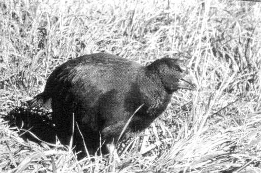 |
| Fig. 5 Takahe a threatened species are located on the island. |
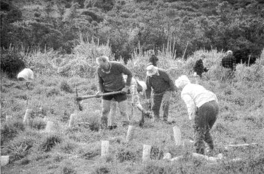 |
| Fig. 6 Volunteer groups contribute significantly to the planting programme. |
Planning the planting
While the early years were aimed at getting initial cover established, the new aim was to achieve ecological homogeneity in the vegetation patterns in order to re-create a landscape, representative of the natural character of the area. To meet this aim, new levels of refinement are slowly being introduced. In the medium term it will result in an improved basis for production planning, where plants are located on site, in what sequence, and over what period.
Examples of the factors that need to be considered are:
| Landscape character: | Cliffs, valleys, plateau, shoreline, wetland. |
| Community type: | Coastal broadleaf, broadleaf/podocarp, coastal shrubland, grassland, herbfield, shoreline. |
| Plant type: | Seral, canopy, sub-canopy, understory, aquatic, threatened. |
| Site factors: | Soil, exposure, aspect, slope, drainage. |
To better illustrate the approach taken at this scale of revegetation planning, I would like to discuss two dissimilar projects.
Plateau basin/forest valley — Kaikomako corridor
The Plateau is one of the most difficult parts of the island on which to grow plants. The vegetation cover is composed of rank grass tending towards a dominance of clumpy Yorkshire fog. The soils are light, drought prone and the undulating edge in particular is subject to wind extremes. The proposal is to revegetate the area with coastal shrubland and coastal broadleaf species to form an initial framework on the edges while allowing open grassland within the basin. Wetland species are regenerating in the valley floor. Takahe and other species such as the giant weta will use the habitat. Being high on the island this is a highly visible area and adjoins a lower corridor linking Forest Valley in the north with Kaikomako valley in the south. Between the two landscape types more sheltered terraces with deeper soil provide a different opportunity for revegetation.
Waikoko Wetland
The second example involves the development of the Waikoko wetland. It is more complex and has involved detailed construction, ecological and landscape design requirements. This project took a low lying and highly modified swamp adjacent to the foreshore and buildings, and restored it to provide:
- Broadleaf/podocarp forest on edge areas
- Divaricating shrubland throughout
- Wetland species including threatened herbs and sedges within the margins
- Fluctuating water levels.
Aquatic species appear to be re-establishing themselves, and along with water quality and chemistry are being carefully monitored.
The water regime is capable of being managed by culverts and systems to assist in habitat establishment for threatened brown teal, fernbird and other species in the long term.
Threatened plants and other key species
The following threatened species have survived on Mana.
| Lepidium oleraceum | Cook's scurvy grass |
| Anogramma leptophylla | Jersey fern |
| Arthropodium cirratum | rengarenga |
| Streblus banksii | large leaved milk tree |
| Melicytus obovatus | |
| Hypolepis dicksoniodes |
With over 160 species of indigenous plants considered to be threatened in the Wellington region and 21 of these in the Wellington Ecological District, it is considered that Mana Island should provide opportunities in the future for safeguarding a wider range than occurs at present. A main criterion of the Restoration Plan states that these must be self-sustaining populations so that further human intervention is minimal. One introduced threatened plant, Gahnia rigida has been planted in the wetland as part of that project. Other past attempts have included Lophomyrtus obcordata and Pimelia aridula.
As a result of Isobel Gabites' work, and a heightened awareness by staff and others involved in the sourcing of propagating material within the ecological area, the species range and location of difficult to find trees and shrubs has greatly improved. Most of these are within reserve areas, private land or covenant areas. It has resulted in the potential species list for basic revegetation work increasing to 60 species (originally 36 of which 22 were from Mana).
Earlier I referred to the akeake specimen found in the wetland. This is a potential seral species that was once presumed common but reduced to only three sites on the coast. Mature seeding trees have recently been located at Paekakariki and will be used for propagation. The same situation applied in the past to northern rata, Griselinia lucida, Entelea arborescens, and others. In this respect Whitireia Park, Plimmerton Bush, Pauatahanui Estuary, Pukerua Bay and Paekakariki areas all provide important sites for sourcing material. An important by-product of this on going work has been the heightened awareness evident from landowners and local residents.
Community Involvement and the Future
It would be a gross injustice not to mention the support the Department has received from the broader community over the years that the restoration work has been underway. Community groups have had a wide involvement in all phases of the revegetation work, research, seed collecting, nursery work, planting, and after care. The Royal Forest and Bird Protection Society, Wellington Botanical Society, the recently formed Friends of Mana and others have enabled a broad spectrum of the interested population to visit Mana and participate in the work.
I believe there is the opportunity for a more extensive and educative role as the programme is further refined and as nature begins to provide uniformity to the plant communities and habitat. Gradually the landscape will change and become more representative with a character of its own. In doing so may it provide a source of inspiration.
In closing I would like to take a further comment from our soil scientist H. S. Gibb. In his paper on the Soils of Wellington, he produced a 'take home thought'."The soils of Wellington reflect the people of Wellington." I would like to be bold enough add a further word or two "The soils and the plants of Wellington reflect the people of Wellington."
![]()
- View
this paper as a PDF of the original proceedings

- Full
conference proceedings available as a hardcopy from the RNZIH
Reproduced from: New Zealand Plants and their Story
Proceedings of a conference held in Wellington, 1-3 October 1999
ISBN 0-9597756-3-3
Home | Journal
| Newsletter | Conferences
Awards | Join
RNZIH | RNZIH Directory | Links
© 20002024 Royal New Zealand Institute of Horticulture
Last updated: April 25, 2004